 |
|
Town/City: |
Port Louis |
State/Province: |
Port Louis |
Country: |
Mauritius |
Latitude/Longitude: |
20° 09' S & 57° 30' E |
Information supplied byDaphne Wellman
98wellma@utsc.utoronto.ca
Dated Mon Nov 19 10:35:48 2001 |
|
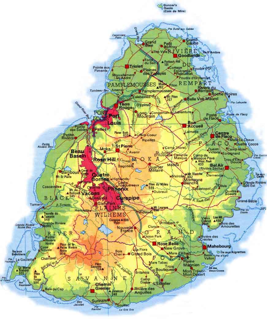 Port
Louis is the capital and main port of the small volcanic island of Mauritius.
Its administrative and economic center is part of a larger, arched urban area
that stretches diagonally across the country from Port Louis to the central plateau
(see map). This urban area developed as a result of bursting activity in the early
1980s as the country moved from an agricultural based economy to a more diverse
economy. Port Louis has a population of 132 460 (1990 census) which roughly
represents 10% of the countrys total population. Like most modern cities, its
metropolitan population is composed of a variety of ethnic groups. This ethnic
diversity however, is consequent of its colonial past and can be seen in the population
at large as well. Its claim to fame in the outside world is its high quality
port that, prior to the opening of the Suez Canal, was the favoured docking site
for large merchant ships travelling trade routes. It was also home to the
infamous dodo bird.
Port
Louis is the capital and main port of the small volcanic island of Mauritius.
Its administrative and economic center is part of a larger, arched urban area
that stretches diagonally across the country from Port Louis to the central plateau
(see map). This urban area developed as a result of bursting activity in the early
1980s as the country moved from an agricultural based economy to a more diverse
economy. Port Louis has a population of 132 460 (1990 census) which roughly
represents 10% of the countrys total population. Like most modern cities, its
metropolitan population is composed of a variety of ethnic groups. This ethnic
diversity however, is consequent of its colonial past and can be seen in the population
at large as well. Its claim to fame in the outside world is its high quality
port that, prior to the opening of the Suez Canal, was the favoured docking site
for large merchant ships travelling trade routes. It was also home to the
infamous dodo bird.
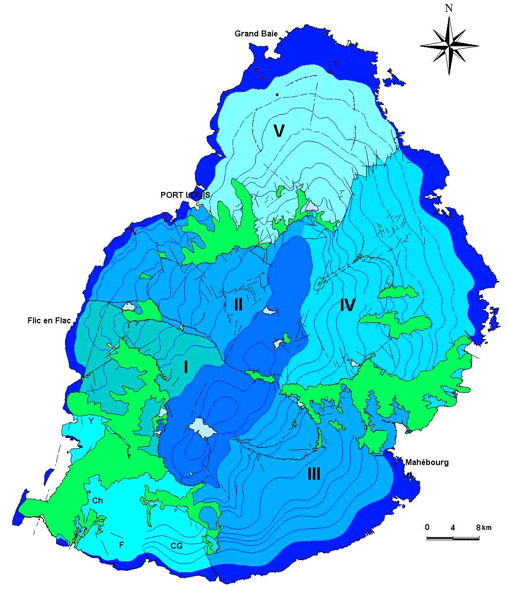
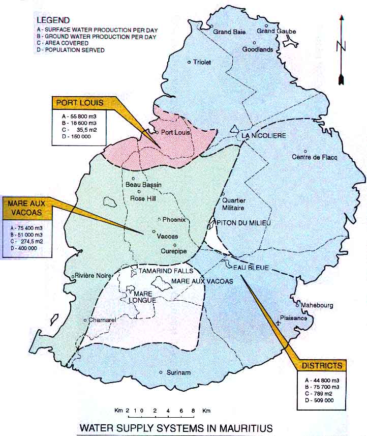
The island of Mauritius formed as a result of two major periods of volcanic activity. The first of these began some 10 million years ago as the African and Australo-Indian tectonic plates were diverging. It was this divergence that was ultimately responsible for the surfacing of basaltic materials and the emergence of the island as one huge shield volcano. At some point this shield volcano collapsed in upon itself creating a caldera complex that gave rise to the islands central plateau and three surrounding mountain ranges. The more recent period of volcanic activity which began some 3.5 million years ago was due to the rising of magma through fractures and fissures of the collapsed caldera complex. This produced a northward moving chain of small volcanoes that poured layers upon layers of lava towards the ocean forming the fertile coastal plain in the north. These layers are much more permeable than the older basaltic layers. They drain precipitation from the central plateau towards the north. There are also faults and dykes lined with intrusive rock along the ancient lava flow path that further encourage water drainage towards the north. The one thing that impedes northward drainage of water in this geologic formation is the presence of clay beds. There are four other aquifers that have been identified on the island. All have the central plateau as the common recharge area. The district of Port Louis and Port Louis itself draws approximately half of its municipal water supply from the reservoirs of these aquifers. The other half is obtained from surface water supplies.
Central Electricity Board (Au.) (2001, June 19-last update). Power Plants [Homepage of the Central Electricity Board], [Online]. Available: http://ceb.intnet.mu/Generation/Plants.htm [2001, October 12]
Central Statistical Office (CSO) (Au.) (2001, April 10-last update). Demographic characteristics of the resident population at the 1990 Census according to boundaries revised in 1991 1992 [Homepage of Ministry of Economic Development, Financial Services and Corporate Affairs], [Online]. Available: http://ncb.intnet.mu/medrc/housing/table2.htm [2001, October 4]
Central Water Authority (Au.) (2001,April 20-last update). Sources of Water [Homepage of the Central Water Authority], [Online]. Available: http://ncb.intnet.mu/putil/cwa/sources.htm [2001, October 12]
COMPNet USA-MAURITIUS (Au.) (2000-copyright). Capital City & Other major cities [Homepage of Mauritius Island Online], [Online]. Available: http://www.maurinet.com/cities.html [2001, October 4]
Eland Systems Limited (Au.) (2001-copyright). Mauritius [Homepage of Eland Newsroom], [Online]. Available: http://www.elandnews.com/mauritius/weather.html [2001, October 4]
Facknath, S. and B. Lalljee (Au.) (1999, August-copyright), Soil and Crop Management for Improved Water Use Efficiency in Agriculture under Conditions of Water Stress [Homepage of PROSI Magazine], [Online]. Available: http://www.prosi.net/mag99/367aug/soil367.htm [2001, October 13]
The Hutchinson Family Encyclopedia, Online Edition (Au.) (1999-copyright). Mauritius [Homepage of WHSmith.co.uk], [Online]. Available: http://ebooks.whsmithonline.co.uk/encyclopedia/10/C0000110.htm [2001, October 11]
Institute For Environmental and Legal Studies (Au.) (2001, August 14-last update). Mauritius and its environment [Homepage of the Institute For Environmental and Legal Studies], [Online]. Available: http://www.intnet.mu/iels/index.htm [2001, October 13]
Jootun, L., M. Bhikajee, R. Prayag and R Soyfoo (Au.) (2001, March 31-last update) Strategic Action Plan for Land-Based Sources and Activities Affecting the Marine, Coastal and Associated Fresh Water Environment in the Eastern African Region [Homepage of the United Nations Environment Programme Eastern Africa], [Online]. Available: http://www.unep.org/eaf/Docs/SAPEaf5/maurit.htm [2001, October 13]
Ministry of Public Utilities (Au.) (1999, October 25-last update). Water Resources unit [Homepage of the Ministry of Public Utilities], [Online]. Available: http://ncb.intnet.mu/putil/wateresc/index.htm [2001, October 13]
Patrice, Raynard (Au.) (1999, March-last update). Ile Maurice [Homepage of Raynard Patrice], [Online]. Available: http://perso.club-internet.fr/erra/RAYNARD/expose.htm [2001, Ocotber 12]
Water Resources Unit (Au.) (1997-copyright). Structure schématique de l'Ile Maurice [Homepage of the Water Resources Unit], [Online]. Available: http://www.refer.org/mrice_ct/cop/wru/ [2001, October 12]